L’ampio uso delle auto, i mezzi pubblici scarsi e la sua conformazione geografica hanno portato la città laziale a sforare i limiti di legge sulle polveri sottili più della Pianura Padana
di Angelo Mastrandrea
https://www.ilpost.it/2024/03/12/frosinone-inquinamento/
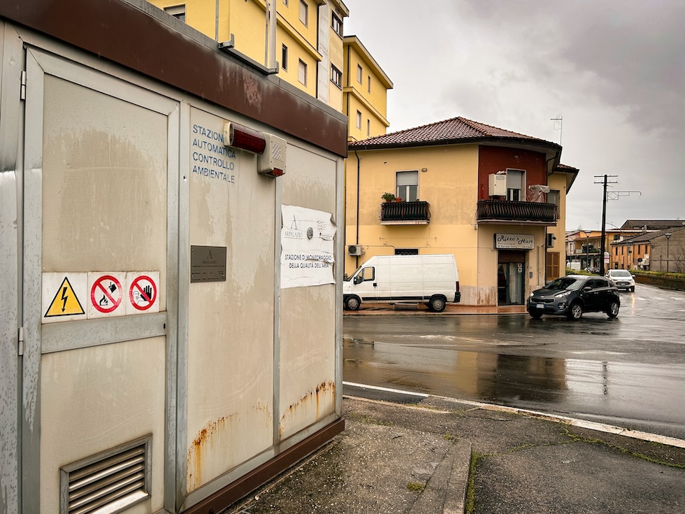
Mercoledì 28 febbraio la centralina per il monitoraggio dell’aria che l’ARPA del Lazio (Agenzia Regionale per la Protezione Ambientale) ha installato lungo viale Mazzini, nel centro di Frosinone, ha rilevato 52 microgrammi per metro cubo di PM10, le particelle più fini prodotte soprattutto dagli scarichi delle automobili e dai riscaldamenti domestici. Un secondo sensore, piazzato all’angolo tra via Puccini e via Verdi, nella parte bassa della città, ha segnalato poco meno e ciò è bastato a evitare l’ennesimo blocco del traffico.
La soglia massima prevista dalla legge italiana infatti è di 50 microgrammi per metro cubo, cinque in più dei 45 indicati dall’Organizzazione Mondiale della Sanità, l’OMS. Quando viene superata, i sindaci devono prendere delle misure di emergenza per far abbassare la concentrazione di PM10 nell’atmosfera ed evitare rischi per la salute dei cittadini, in particolare delle persone anziane, dei bambini e di chi è affetto da malattie respiratorie. Queste particelle, infatti, spesso sono composte da metalli pesanti, nitriti e solfati, e quando vengono respirate possono provocare problemi respiratori come asma o bronchiti croniche, malattie cardiovascolari e tumori come quello al polmone.
Secondo un rapporto di Legambiente, nel 2023 Frosinone è stata la città italiana che ha sforato più volte il limite dei 50 microgrammi al metro cubo di PM10. La stazione di monitoraggio dell’aria di Frosinone Scalo ha rilevato che la soglia critica è stata superata per 70 giorni, più o meno un giorno a settimana, mentre una direttiva europea del 2008 e la legge del 2010 che l’ha recepita stabiliscono che il limite non vada superato per più di 35 giorni all’anno. Per la seconda volta negli ultimi dieci anni Frosinone è risultata più inquinata da polveri sottili, come vengono definite queste particelle, di città come Milano, Napoli, Roma e Torino, e della Pianura Padana, dove a Gennaio la soglia dei 50 microgrammi per metro cubo d’aria è stata superata per diversi giorni.
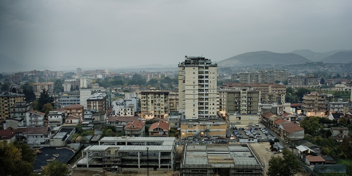
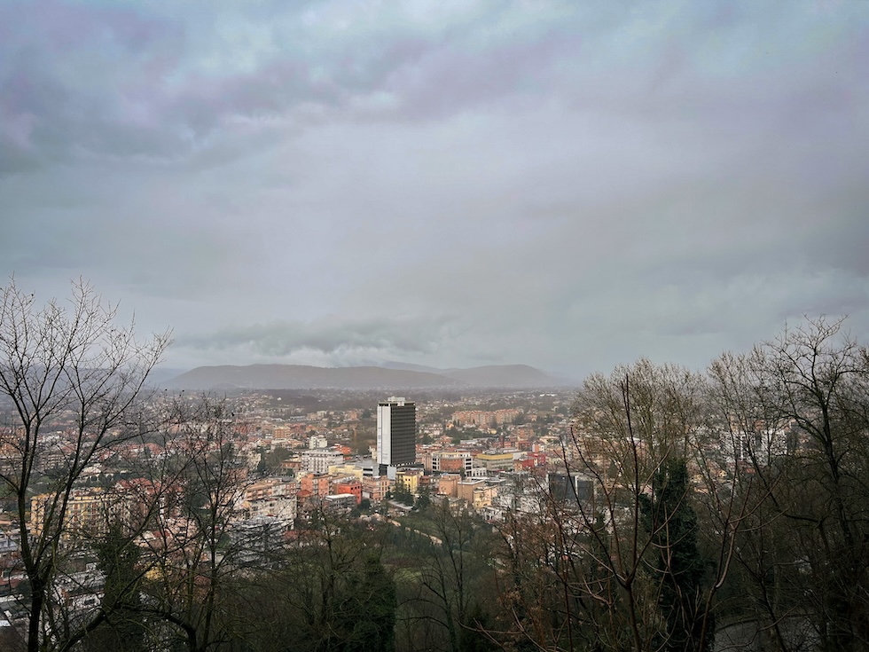
A Frosinone Scalo vive la maggior parte dei 44mila abitanti di Frosinone, che è la città più importante della regione storica del Lazio chiamata Ciociaria. Quasi altrettanti ci vanno ogni giorno dai paesi vicini per lavorare. Lo svincolo dove si trova la centralina è uno dei punti più trafficati della città. Per questo molti abitanti ritengono che i dati sull’inquinamento siano falsati e che in realtà il resto della città non sia poi così inquinato. Il sindaco Riccardo Mastrangeli, di Forza Italia, però li smentisce. «Negli ultimi tempi abbiamo rilevato un alto livello di polveri sottili anche nella parte alta della città, che in genere ha l’aria più pulita di quella bassa, dove lo smog ristagna perché si trova in una conca tra i monti Lepini e i monti Ernici», dice.
Gli unici giorni in cui il PM10 è tornato al di sotto dei limiti di legge sono stati quelli in cui il vento o la pioggia ne hanno ridotto la concentrazione.

Mastrangeli, che è anche un farmacista, dice che Frosinone è la prima città nel Lazio per vendita di farmaci cortisonici inalatori. Ogni mattina Mastrangeli controlla su un’app i livelli di polveri sottili presenti nell’aria, secondo i dati rilevati dalle due centraline, e sulla base di questi decide i provvedimenti per ridurne rapidamente la quantità. I continui sforamenti della soglia considerata pericolosa per la salute umana lo hanno costretto a decretare in diverse occasioni il blocco del traffico per le auto più inquinanti e hanno convinto la giunta comunale di centrodestra a programmare alcuni interventi strutturali, per cambiare la mobilità cittadina e gli impianti di riscaldamento.
Tra i provvedimenti adottati ci sono l’acquisto di bus elettrici, che saranno pagati con i fondi del Piano Nazionale di Ripresa e Resilienza (PNRR) finanziato dall’Unione Europea, la realizzazione di una rete di parcheggi di scambio in cui lasciare l’auto e prendere un mezzo pubblico, e l’invio di tecnici del comune in case e palazzi per controllare ed eventualmente sostituire le vecchie caldaie con altre meno inquinanti.
Il PM10 viene chiamato in questo modo perché le particelle di cui è composto, che possono essere liquide o solide, hanno un diametro uguale o non superiore ai 10 micron, cioè 10 millesimi di millimetro. Si distingue dal PM2.5, che è costituito da polveri ancora più fini, che se vengono respirate penetrano più in profondità nelle vie respiratorie. Il Ministero della Salute spiega che può avere «sia un’origine naturale, come l’erosione dei venti sulle rocce, le eruzioni vulcaniche e l’autocombustione di boschi e foreste, sia antropica», cioè dagli scarichi delle automobili o dei riscaldamenti domestici, compresi i vecchi camini a legna. Per questo Mastrangeli ha anche vietato l’uso di camini e stufe a legna nelle case che hanno già altri impianti di riscaldamento e ha proibito ai contadini «l’odiosa abitudine» di bruciare le sterpaglie all’aperto (roghi agricoli) «nonostante abbiamo predisposto un servizio di raccolta gratuita».
Il segretario locale di Legambiente Stefano Ceccarelli sostiene che per abbattere la quantità di polveri sottili sia necessario cambiare radicalmente la mobilità cittadina e abbassare i limiti di velocità sulla vicina autostrada nel tratto in cui attraversa la provincia di Frosinone. L’associazione ambientalista si appella a una legge del 2023, firmata dal Ministro dei Trasporti Matteo Salvini, che ha concesso alle Regioni la facoltà di imporre l’abbassamento dei limiti di velocità sulle autostrade proprio per ridurre l’inquinamento. «Ogni giorno sulla Roma-Napoli passano circa 50mila vetture e a queste si aggiungono quelle delle decine di migliaia di persone che vengono a lavorare in città con la propria automobile», spiega. Secondo dati ISTAT, a Frosinone c’è il numero di automobili più alto in Italia, 829 ogni 1.000 abitanti.
«Bisogna convincere i cittadini che molti percorsi si possono fare anche a piedi ed è necessario rivedere la frequenza e la capillarità del trasporto pubblico», dice Marina Testa, coordinatrice della Federazione Italiana Ambiente e Bicicletta (FIAB) nel Lazio. Secondo Ceccarelli, l’«abitudine consolidata» di prendere l’auto spesso è obbligata, perché «la conformazione urbanistica caotica di Frosinone», che è fatta nella parte bassa di centinaia di villette e palazzine sparse nelle campagne, rende quasi impossibile il ricorso a un mezzo diverso da quello privato. «Purtroppo la città dagli anni Sessanta è stata costruita in maniera disordinata e senza alcuna sensibilità ambientale e ora non è facile rimediare ai danni fatti», dice Testa. La misura di tutto questo secondo lei è il modo in cui venne trattato un antico anfiteatro romano: alla metà degli anni Sessanta fu scoperto dalle ruspe che lavoravano per costruire un palazzo. La costruzione fu interrotta ma poi riprese, e quello che rimane è nascosto sotto un edificio di via Roma, una delle strade principali di Frosinone.
La Federazione Italiana Ambiente e Bicicletta (FIAB) si sta battendo contro la riapertura dell’unica strada chiusa al traffico. È lunga 450 metri e collega la villa comunale alla via che porta sui vicini monti Lepini, attraversando un parco e una pista di pattinaggio abbandonata: è stata chiusa per via di un ponticello pericolante che non è mai stato sistemato. Testa la definisce «un piccolo polmone incastonato tra gli edifici, uno dei pochi posti della città in cui si può respirare». Lungo la strada si vedono persone a passeggio, di corsa o in bicicletta, «perché altri percorsi utilizzabili non ci sono a meno che non si faccia una fuga tra i campi».
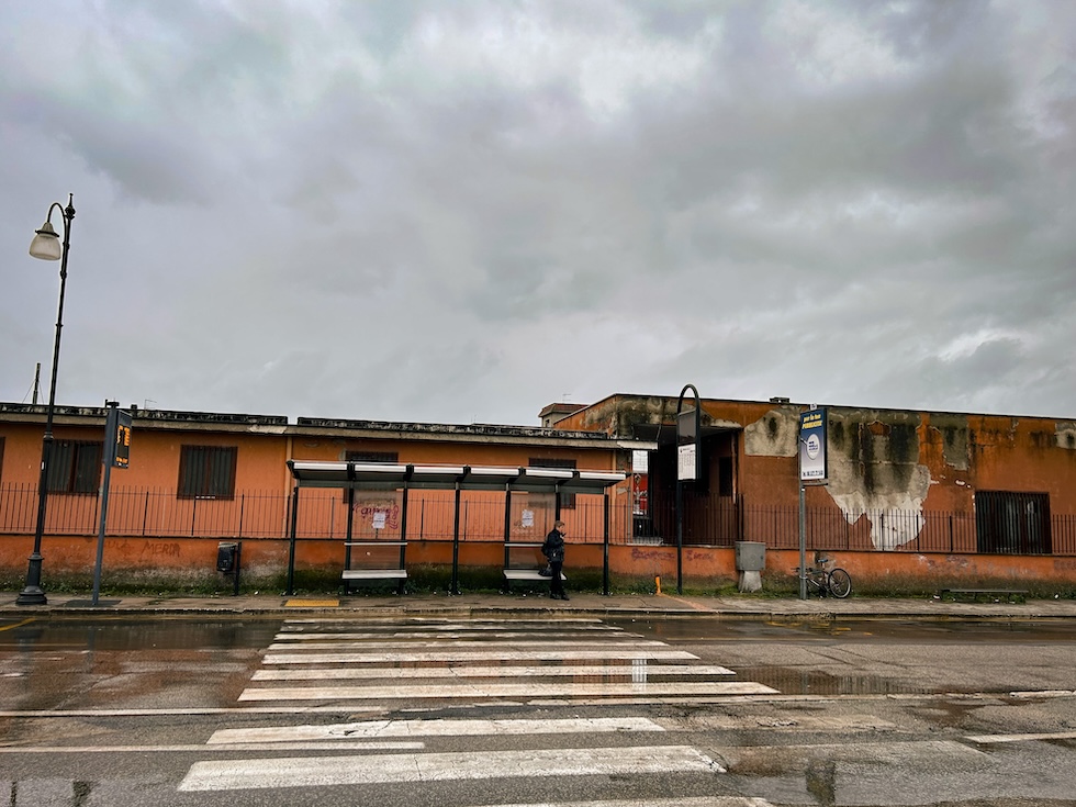
I bus del trasporto pubblico locale vengono utilizzati poco perché in molte zone della città non arrivano e passano molto di rado. Per andare dalla stazione ferroviaria al grattacielo Zeppieri nel quartiere De Matthaeis, che è il centro economico della città bassa, ci vorrebbero non più di una decina di minuti. Una linea diretta verso il centro storico avrebbe più o meno gli stessi tempi di percorrenza. Ma i tempi di attesa degli autobus vanno da mezzora a un’ora, e inoltre fanno percorsi tortuosi per coprire con le poche corse a disposizione più territorio possibile.
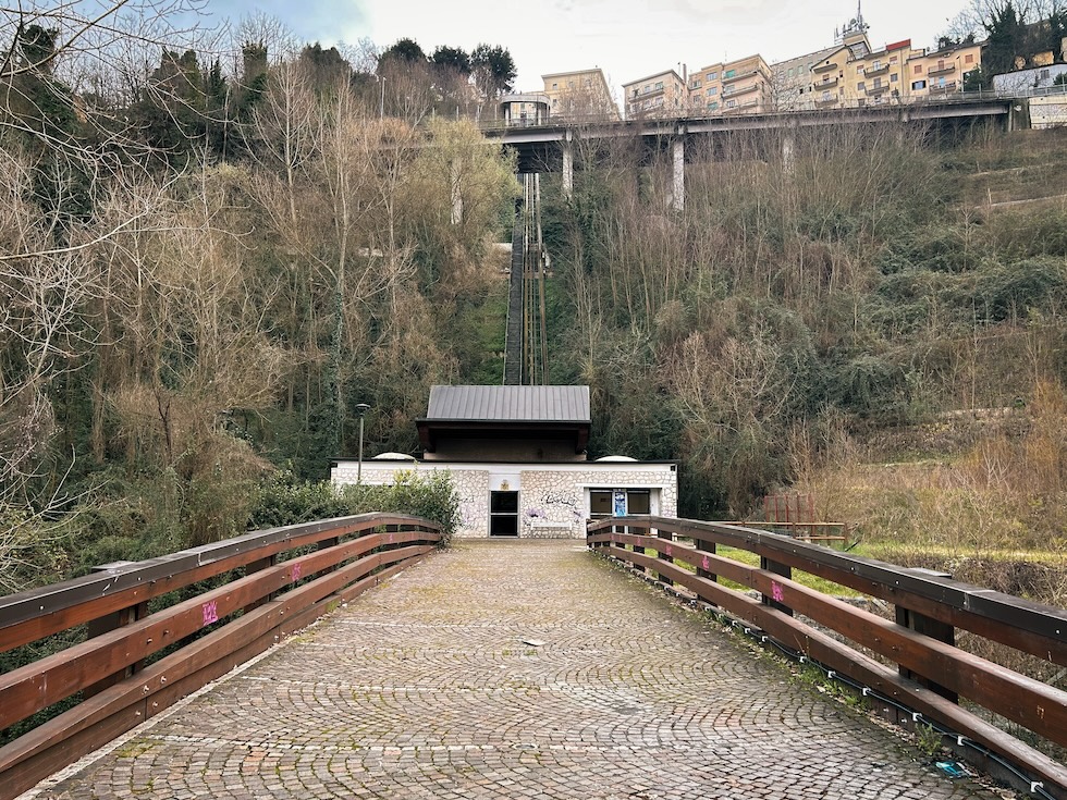
L’«ascensore inclinato», una sorta di funivia con una cabina da 30 posti che dovrebbe portare alla parte alta superando un dislivello di 170 metri, è rotto da tre anni. La giunta comunale ha appaltato i lavori per potenziarlo, mentre i nuovi bus elettrici dovrebbero collegarlo direttamente alla stazione. «Per rendere appetibile il trasporto pubblico locale ti devi muovere dalla stazione al centro storico in dieci minuti, per questo è necessario raddoppiare l’ascensore inclinato e inserirlo in un piano urbano sostenibile», ha detto il sindaco Mastrangeli in consiglio comunale. Al momento, però, il mezzo più veloce per andare nel centro storico, dove si trovano l’Accademia di Belle Arti e il Museo Archeologico, rimane l’automobile.
Fonte: Il Post
English translate
WHY FROSINONE IS ONE OF THE MOST POLLUTED CITIES IN ITALY
The widespread use of cars, limited public transport and its geographical conformation have led the Lazio city to exceed the legal limits on fine particles more than the Po Valley
by Angelo Mastrandrea

On Wednesday 28 February the air monitoring unit that the ARPA of Lazio (Regional Agency for Environmental Protection) installed along Viale Mazzini, in the center of Frosinone, detected 52 micrograms per cubic meter of PM10, the finest particles produced mainly by car exhaust and home heating. A second sensor, placed on the corner between via Puccini and via Verdi, in the lower part of the city, reported slightly less and this was enough to avoid yet another traffic block.
The maximum threshold established by Italian law is in fact 50 micrograms per cubic meter, five more than the 45 indicated by the World Health Organization, the WHO. When it is exceeded, mayors must take emergency measures to lower the concentration of PM10 in the atmosphere and avoid risks to the health of citizens, in particular elderly people, children and those suffering from respiratory diseases: these particles, in fact, are often composed of heavy metals, nitrites and sulphates, and when they are breathed in they can cause respiratory problems such as asthma or chronic bronchitis, cardiovascular diseases and tumors such as lung cancer.
According to a Legambiente report, in 2023 Frosinone was the Italian city that exceeded the limit of 50 micrograms per cubic meter of PM10 several times. The Frosinone Scalo air monitoring station found that the critical threshold was exceeded for 70 days, more or less one day a week, while a 2008 European directive and the 2010 law that implemented it establish that the limit must not be exceeded for more than 35 days per year. For the second time in the last ten years, Frosinone was more polluted by fine dust, as these particles are defined, than cities such as Milan, Naples, Rome and Turin, and the Po Valley, where in January the threshold of 50 micrograms per cubic meter of air was exceeded for several days.

Most of the 44 thousand inhabitants of Frosinone live in Frosinone Scalo, which is the most important city in the historical region of Lazio called Ciociaria. Almost as many go there every day from neighboring towns to work. The junction where the control unit is located is one of the busiest points in the city. For this reason, many inhabitants believe that the pollution data are distorted and that in reality the rest of the city is not that polluted. Mayor Riccardo Mastrangeli, of Forza Italia, however, denies them. «Recently we have detected a high level of fine dust even in the upper part of the city, which generally has cleaner air than the lower part, where smog stagnates because it is located in a valley between the Lepini and Ernici mountains», he says.
The only days in which PM10 returned to below legal limits were those in which wind or rain reduced its concentration.

Mastrangeli, who is also a pharmacist, says that Frosinone is the first city in Lazio for the sale of inhaled cortisone drugs. Every morning Mastrangeli checks the levels of fine dust present in the air on an app, according to the data collected by the two control units, and on the basis of these decides on measures to quickly reduce the quantity. The continuous exceeding of the threshold considered dangerous for human health have forced him to decree on several occasions the blocking of traffic for the most polluting cars and have convinced the centre-right municipal council to plan some structural interventions to change city mobility and systems of heating.
Among the measures adopted are the purchase of electric buses, which will be paid for with funds from the National Recovery and Resilience Plan (PNRR) financed by the European Union, the creation of a network of exchange car parks where you can leave your car and taking public transport, and sending municipal technicians to houses and buildings to check and possibly replace old boilers with less polluting ones.

PM10 is called in this way because the particles of which it is composed, which can be liquid or solid, have a diameter equal to or no greater than 10 microns, i.e. 10 thousandths of a millimetre. It’s distinguished from PM2.5, which is made up of even finer dust, which if breathed penetrates deeper into the respiratory tract. The Ministry of Health explains that it can have “both a natural origin, such as the erosion of winds on rocks, volcanic eruptions and spontaneous combustion of woods and forests, and anthropic“, i.e. from car exhaust or home heating, including old wood-burning fireplaces. For this reason Mastrangeli also banned the use of fireplaces and wood stoves in homes that already have other heating systems and prohibited farmers from “the hateful habit” of burning brushwood in the open air (agricultural fires) “despite the fact that we have set up a collection service free.”
The local secretary of Legambiente Stefano Ceccarelli claims that to reduce the quantity of fine particles it’s necessary to radically change city mobility and lower the speed limits on the nearby motorway in the stretch where it crosses the province of Frosinone. The environmentalist association is appealing to a 2023 law, signed by the Minister of Transport Matteo Salvini, which garanted the Regions the power to impose the lowering of speed limits on motorways precisely to reduce pollution. «Every day about 50 thousand cars pass on the Rome-Naples route and to these must be added those of the tens of thousands of people who come to work in the city with their own cars», he explains. According to ISTAT data, in Frosinone there is the highest number of cars in Italy, 829 per 1,000 inhabitants.
«We need to convince citizens that many routes can also be done on foot and it is necessary to review the frequency and capillarity of public transport», says Marina Testa, coordinator of the Italian Environment and Bicycle Federation (FIAB) in Lazio. According to Ceccarelli, the «consolidated habit» of taking the car is often obligatory because «the chaotic urban layout of Frosinone», which is made up of hundreds of villas and buildings scattered in the countryside in the lower part, makes it almost impossible to use a means other than private. «Unfortunately, since the 1960s the city has been built in a disorderly manner and without any environmental sensitivity and now it’s not easy to remedy the damage done», says Testa. According to her, the measure of all this is the way in which an ancient Roman amphitheater was treated: in the mid-1960s it was discovered by bulldozers working to build a palace. Construction was interrupted but then resumed, and what remains is hidden under a building on Via Roma, one of Frosinone’s main streets.

The Italian Environment and Bicycle Federation (FIAB) is fighting against the reopening of the only road closed to traffic. It’s 450 meters long and connects the municipal villa to the road that leads to the nearby Lepini mountains, crossing a park and an abandoned ice rink: it was closed due to a small unsafe bridge that was never repaired. Testa defines it as “a small lung nestled between the buildings, one of the few places in the city where you can breathe”. Along the road you can see people walking, running or cycling, “because there are no other usable routes unless you escape through the fields”.

Local public transport buses are rarely used because they rarely arrive or pass through many areas of the city. To go from the train station to the Zeppieri skyscraper in the De Matthaeis district, which is the economic center of the lower city, would take no more than about ten minutes. A direct line to the historic center would have more or less the same travel times. But bus waiting times range from half an hour to an hour, and they also take tortuous routes to cover as much territory as possible with the few trips available.
The “inclined lift”, a sort of cable car with a 30-seater cabin that should lead to the upper part over a difference in height of 170 metres, has been broken for three years. The municipal council has contracted the works to upgrade it, while the new electric buses should connect it directly to the station. «To make local public transport attractive you have to move from the station to the historic center in ten minutes, which is why it’s necessary to double the inclined lift and insert it into a sustainable urban plan», Mayor Mastrangeli said in the city council. At the moment, however, the fastest way to go to the historic centre, where the Academy of Fine Arts and the Archaeological Museum are located, remains the car.

Source: Il Post

https://www.google.it/maps/place/03100+Frosinone+FR/@41.6346093,13.2964801,8945m/data=!3m2!1e3!4b1!4m6!3m5!1s0x13255a94c5214bd7:0xc5572b2113e85906!8m2!3d41.6396009!4d13.3426341!16s%2Fg%2F11bc5v280r?entry=ttu
https://x.com/bralex84/status/1768746642792906886
Smog alle stelle, quattro giorni di stop alle auto in centro a Frosinone
I divieti applicati dopo l’ennesimo sforamento dei limiti delle polveri sottili. Quattro giorni di limitazioni alla circolazione da oggi fino a lunedì. E il 25 torna anche la domenica ecologica

https://www.rainews.it/tgr/lazio/articoli/2024/02/smog-alle-stelle-quattro-giorni-di-stop-alle-auto-in-centro-a-frosinone-583d72de-2acb-4e03-85b9-771f24267804.html
Lo smog non accenna ad abbandonare l’aria di Frosinone. Le centraline di rilevamento dell’Agenzia Regionale per la Protezione dell’Ambiente hanno registrato un nuovo sforamento dei limiti delle polveri sottili. Per questo il sindaco Riccardo Mastrangeli ha firmato un provvedimento con il quale ancora una volta viene limitata la circolazione dei mezzi più inquinanti nel centro cittadino. Lo stop è partito questa mattina 23 febbraio e si estenderà fino a tutto il 26.
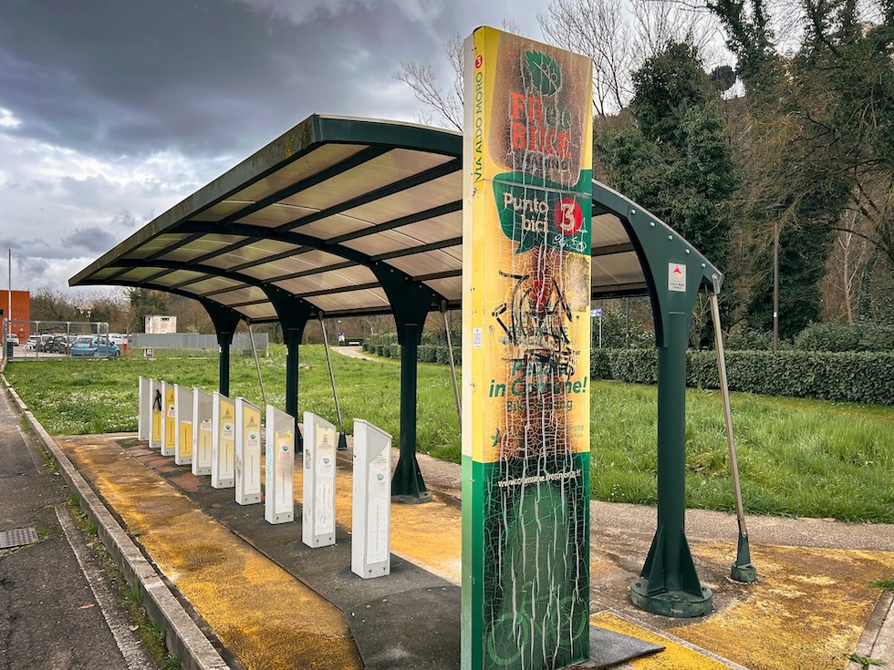
A Frosinone la centralina di via Puccini ha misurato nella giornata di sabato 61 microgrammi al metro cubo di pm10, il limite è 50 microgammi. E mentre la pioggia tornata a scendere in città proprio questa mattina dopo tanti giorni di assenza, lascia ben sperare, il comune di Frosinone intende continuare a promuovere comportamenti virtuosi a favore dell’ecosistema e per tutelare la salute della collettività. Così domenica 25 febbraio torna la seconda domenica ecologica. In particolare la città ospiterà nell’area di via Aldo Moro una serie di iniziative al cui centro ci sono il benessere e gli stili di vita. Sarà possibile partecipare a lezioni dimostrative di pizzica, danza, hip hop e canottaggio indoor.
Nel servizio di Gemma Giovannelli l’intervista a Giancarlo Pizzutelli – Direttore Dipartimento Prevenzione ASL Frosinone.
Fonte: Rainews
English translate
Skyrocketing smog, four days of car closures in the center of Frosinone
The bans applied after yet another violation of the limits of fine dust. Four days of traffic restrictions from today until Monday. And ecological Sunday also returns on the 25th

The smog shows no signs of abandoning the air of Frosinone. The detection stations of the Regional Agency for Environmental Protection have recorded a new violation of the limits of fine particles. For this reason, the mayor Riccardo Mastrangeli has signed a provision with which the circulation of the most polluting vehicles in the city center is once again limited. The stop started this morning February 23rd and will extend until the end of the 26th.
In Frosinone the control unit in via Puccini measured 61 micrograms per cubic meter of pm10 on Saturday, the limit is 50 microgammas. And while the rain returned to the city this morning after many days of absence gives rise to hope, the municipality of Frosinone intends to continue to promote virtuous behavior in favor of the ecosystem and to protect the health of the community. So on Sunday February 25th the second Ecological Sunday returns. In particular, the city will host a series of initiatives in the Via Aldo Moro area whose focus is on wellbeing and lifestyles. It will be possible to participate in demonstration lessons of pizzica, dance, hip hop and indoor rowing.
Source: Rainews
Dott. Alessio Brancaccio, tecnico ambientale Università degli Studi di L’Aquila, membro della Fondazione Michele Scarponi Onlus, ideologo e membro del movimento ambientalista Ultima Generazione A22 Network per contrastare il Riscaldamento Globale indotto artificialmente